| Earlier on this year you may recall that we told you about a new android app about the popular 96 mile long distance path: the West Highland Way. Well, here at Mountain Hikes UK, we have just got our hands on a copy courtesy of our friends at Calton Hill. Plus, we just received news that a guide to the Cotswold Way is out on the 05/10/12. Heres what we thought and some more information on the new Cotswold Way app... | |
West Highland Way App Review
At first you are struck by the simplicity of it: everything is laid out for you to see and there are no hidden extras. The fact that the app may have to be used in famous British weather was obviously considered when the app was made as the buttons are large and easy to use when you are in a rush or when you are in thick fog and visibility between your face and the phone is bad.
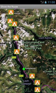
Viewing Campsites ©Calton Hill
You have the ability to plan before you walk easily by either looking at the route in segments or as a whole. Planning includes the ability to add your own places of interest and to customize segments. Each segment also has detail of the amount of ascent, descent and total distance. A nice addition is the ability to view places along the way such as campsites, restaurants but most impressively you can view the main mountains/hills along the route which can be narrowed down to just Munros. Great if you want to bag a few famous hills along the way. Maybe you could pop up Ben Nevis at the end as an extra treat (assuming you're not completely shattered).
Once you have finished planning you can walk the route aided by the GPS compatibility (obviously the accuracy of it depends upon the phone you are using). Safety note: you should never rely solely on GPS and should always carry a map and compass. Both the planning and walking features are built around Google Maps Imagery which can be switched between satellite and road map view. Whilst walking you can view how far away you are from your campsite by using the 'show distance from here' tool.
Once you are in the comfort (or uncomfort) of your accommodation for the night you can make a diary of your day that can be emailed to friends. Also you can view the diary entries on the route map to review what you thought about a certain section. There is also the ability to change the units of distance depending on if you have gone metric yet or not.
All of this is available for £1.99 from the Android Store.
The Cotswold Way App
Available from today you can buy the second app in the series: the Cotswold Way app. It works in the same way as the West Highland Way app but on the Cotswold Way instead! It is available for the same price as the WHW app (£1.99) from the Android Store.
| For more information contact Alan Lucas.. Alan Lucas Calton Hill LTD 15-19 York Place Edinburgh EH1 3EB United Kingdom Tel: +44 131 558 8500 Email: [email protected] Website: http://www.caltonhillgolf.com/walking/ | OR Download the full press release here...
| ||
 RSS Feed